Data Science for Emergency Services v0.0.1

">

Service coverage monitoring (front-end)

Category: front-end application | Status: Proof of concept

Featured image

GitHub repo
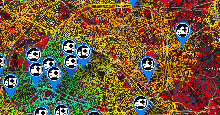
Front-end solution to project in a fast and efficient way a high resolution of a service capacity coverage information for critical dispatch services such as emergency services.

This project is made possible thanks to MapBox GL JS and the self-production of vector tiles which are really small, enabling global high resolution maps, fast map loads, and efficient caching.

placeholder

placeholder

For real time units tracking (UBER like) you could consider this repo: https://github.com/ds4es/real-time-units-gps-tracking

See also

Unit response oracle

date_range 19/06/2020

Featured image

The response time is one of the most important factors for emergency services because their ability to save lives and rescue people depends on it. A non-optimal choice of an emergency vehicle for a rescue request may lengthen the arrival time of the rescuers and impact the future of the victim. This choice is therefore highly critical for emergency services and directly rely on their ability to predict precisely the arrival time of the different units available.

Real-Time Units Gps Tracking

date_range 16/05/2020

Featured image

This project show how to broadcast, consume and plot GPS data in real-time. See the README.md on GitHub for details.

Real-Time Data Replication Between Remote Information Systems

date_range 26/04/2020

Featured image

More than ever people are expecting to share, access and get data processed in real-time. Unfortunately on this subject, public services are lagging far behind the private sector.